DENVER — Multiple advisories are in place ahead of snow and bitter cold that Coloradans will experience for most of the week.
The National Weather Service in Boulder has issued a winter weather advisory for west Jackson and west Grand counties above 9,000 feet from noon Monday to 6 a.m. Tuesday due to snow and winds. Total snow accumulations are expected to be 4 and 9 inches with winds gusting as high as 30 mph, according to NWS.
A wind chill advisory is also in effect for portions of east central and northeast Colorado from midnight to noon Wednesday because wind chills could be as low as 25 below zero, which could cause frostbite in less than 30 minutes.
MORE: Full forecast | Radars | Traffic | Weather Page | 24/7 Weather Stream | 24/7 Radar Stream | Closings and Delays
Monday will be the last day of mild weather, with highs reaching near 50 degrees in the Denver metro area before plummeting for the next few days. Temperatures will drop into the teens and 20s during the afternoon, with northeast winds of 20 to 35 mph.
It’s already snowing in western Colorado, but light snow will become more widespread over the mountains and plains this evening, according to the most recent NWS forecast. Most places will have light snow Monday night with an inch or two possible, but areas in and near the foothills could see up to 4 inches and the northern mountains will see 4 to 8 inches of snow.
Here's the expected snowfall for the first wave of this system. @RockyNPS and the mountains near Steamboat will see the heaviest amounts through Tuesday morning. Not much snow is expected in Denver. The second wave brings more widespread snow late Tuesday through Wednesday. #COwx pic.twitter.com/cLH9InhRVZ
— NWS Boulder (@NWSBoulder) February 21, 2022
The snow and cold will continue over the next few days, NWS said. A break in snowfall is expected sometime Tuesday morning, but it will pick up again across the mountains and into the plains late Tuesday afternoon and evening.
In addition to the snow, highs on Tuesday will struggle to reach double digits, with a high temperature of 10 degrees, which would be a daily record cold maximum temperature, according to NWS. The previous record was 13 degrees set back in 1913.
There may be another quick break in the snowfall Wednesday before another round of light to moderate snow Wednesday into Thursday. The mountains will see an additional 6-12 inches of snow, and 3-7 inches of snow will be possible for the foothills with amounts sharply decreasing into the urban corridor and plains.
Temperatures should warm into the low to mid 10s on Wednesday and the upper teens Thursday.
The snow will taper off by Thursday and temperatures will gradually warm Friday and into the weekend.
The Colorado Avalanche Information Center on Monday said the snowfall will cause avalanche conditions to deteriorate, and natural avalanche activity is expected. In the last seven days, there have been 41 human-triggered avalanches.
Colorado’s statewide snowpack sat at 90% of median Monday. Only one of the eight river basins, the South Platte (101%), was above median levels as of Monday’s data. Three others were close to median levels — Gunnison (99%), Laramie and North Platte (98%) Upper Colorado Headwaters (96%).
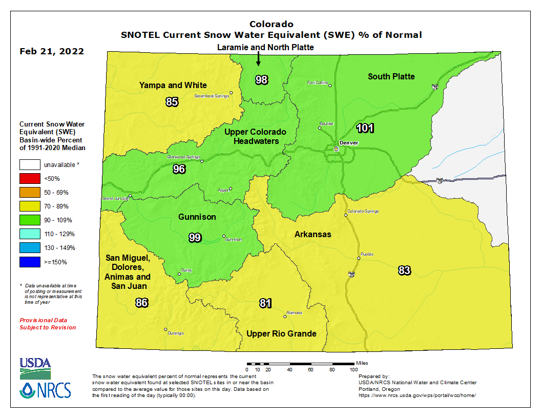
The San Miguel, Dolores, Animas and San Juan (86%), Yampa and White (85%), Arkansas (83%), and Upper Rio Grande (81%) basins were all slightly below median levels.
You can always watch 24/7 weather, radar and news updateson the free Denver7+ app on your TV.
"bitter" - Google News
February 22, 2022 at 02:56AM
https://ift.tt/LeaFr8g
Snow, bitter cold to take over for much of the week - The Denver Channel
"bitter" - Google News
https://ift.tt/KZUb1mW
https://ift.tt/MvpCFeY
Bagikan Berita Ini


0 Response to "Snow, bitter cold to take over for much of the week - The Denver Channel"
Post a Comment