DENVER — Multiple advisories are in place for continued snow and bitter cold that Coloradans will experience for most of the week.
The National Weather Service in Boulder has issued a winter weather advisory from 5 p.m. Tuesday to 5 a.m. Thursday for Rocky Mountain National Park, the Medicine Bow Range, the mountains of Summit County, the Mosquito Range and the Indian Peaks. Approximately 5 and 10
inches of snow is expected, with winds as high as 35 mph.
A wind chill advisory is also in effect for portions of Elbert and Douglas counties as well as portions of east central and northeast Colorado until noon Wednesday because wind chills could be as low as 25 below zero, which could cause frostbite in less than 30 minutes.
MORE: Full forecast | Radars | Traffic | Weather Page | 24/7 Weather Stream | 24/7 Radar Stream | Closings and Delays
The snow and cold will continue over the next few days, NWS said. Snow will pick up again across the mountains and into the plains late Tuesday afternoon and evening, though it's expected to be fairly light.
So far, under two inches of snow fell around the Denver metro area. Southwestern Colorado saw the highest recorded snowfall, with a foot reported in the San Juan Mountains.
In addition to the snow, highs on Tuesday will struggle reach double digits, with a high temperature of 10 degrees, which "will almost certainly" break a daily record cold maximum temperature — 13 degrees in 1913 — according to NWS.
Another inch or two of snow is expected Tuesday night along the I-25 Corridor, with the flow favoring locations farther north, like Fort Collins, the most. One to three inches is expected for the foothills through Wednesday.
There may be another quick break in the snowfall Wednesday before another round of light to moderate snow Wednesday into Thursday. Through Wednesday night, the mountains will see an additional 5-10 inches of snow. Snowfall looks light for Wednesday across the Urban Corridor with little to no snow for the eastern plains.
Temperatures should warm into the low to mid 10s on Wednesday and the upper teens Thursday. The snow will taper off by Thursday and temperatures will gradually warm Friday and into the weekend.
The Colorado Avalanche Information Center on Monday said the snowfall will cause avalanche conditions to deteriorate. An avalanche watch is in effect as of Monday at 4:15 p.m. for the Aspen and Gunnison zones, and other zones will likely fall under a watch on Tuesday, CAIC said.
Natural avalanche activity is expected, and there have been 41 human-triggered avalanches in the last seven days.
Colorado’s statewide snowpack sat at 92% of median Tuesday. Four of the eight river basins were at or just below median levels as of Tuesday's data — Gunnison (100%), the South Platte (99%), Laramie and North Platte (98%), and Upper Colorado Headwaters (96%).
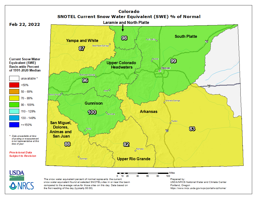
The San Miguel, Dolores, Animas and San Juan (88%), Yampa and White (87%), Arkansas (83%), and Upper Rio Grande (82%) basins were all slightly below median levels.
You can always watch 24/7 weather, radar and news updateson the free Denver7+ app on your TV.
"bitter" - Google News
February 22, 2022 at 02:56AM
https://ift.tt/DqtRZvB
Bitter cold settling in, more snow falling through Thursday - The Denver Channel
"bitter" - Google News
https://ift.tt/9nFAM57
https://ift.tt/Q45ju9p
Bagikan Berita Ini


0 Response to "Bitter cold settling in, more snow falling through Thursday - The Denver Channel"
Post a Comment